
Chapter 2: Infrastructure & Transportation
2.1 Sidewalks and Lighting
2.2 Rand Exit
2.3 Booker T. Washington Heritage Trail
2.4 Landscaping
2.5 Benches and Trashcans
2.6 Community Garden
2.1 Sidewalks and Lighting
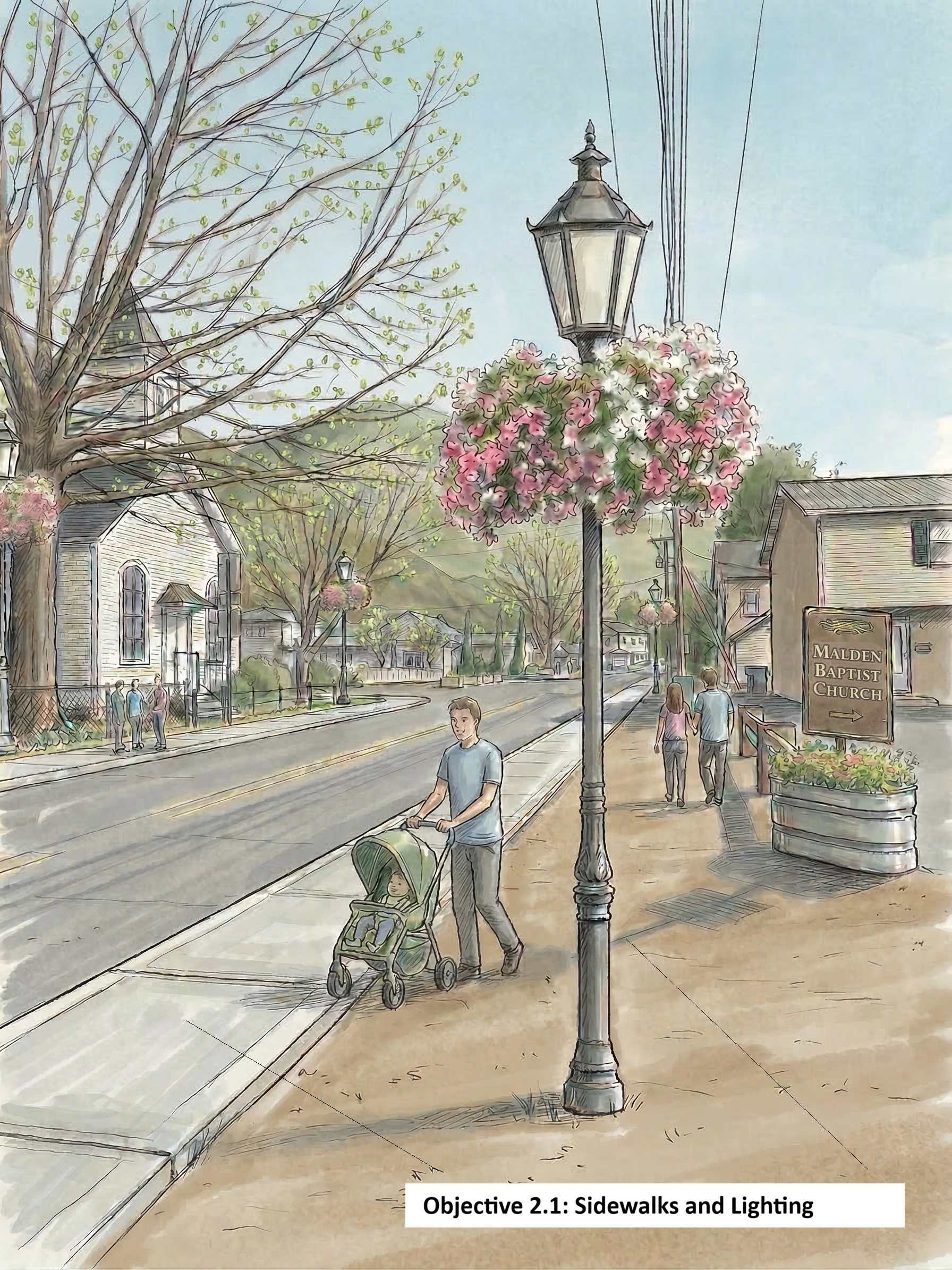
Lighting, Sidewalks, and the Pedestrian Experience in Historic Malden
Safe Movement
The transportation infrastructure of the Malden Historic District is not merely a matter of utility. To establish Malden as a walkable heritage destination, the physical experience of moving through the corridor must be managed as deliberately as the buildings themselves were almost 200 years ago.
Restoration of the 19th-Century Streetscape
The pedestrian environment along Malden Drive requires a unified infrastructure vision that serves multiple populations simultaneously: heritage tourists, residents, local business patrons, and the children who walk to school and to the bus stops each morning.
Period-Appropriate Lighting: Decorative lampposts consistent with late 19th-century design would provide both authentic visual character and functional illumination. These fixtures would also serve as practical infrastructure for seasonal programming, including hanging flower baskets, wreaths, and heritage celebration banners, transforming the streetscape into a year-round curated environment.
Continuous Sidewalk Infrastructure: Gaps in the sidewalk network along a historic corridor are active deterrents to pedestrian activity, heritage tourism, and child safety. A continuous, ADA-compliant sidewalk network is the foundation upon which all other district programming rests.
An Aging Population with Immediate Infrastructure Needs
The demographic profile of Malden makes accessible, safe pedestrian infrastructure an urgent necessity. According to the most recent American Community Survey data, Malden's median age is 70.4 years, more than 1.5 times both the Charleston metropolitan area median of 44 years and the West Virginia state median of 42.7 years (U.S. Census Bureau, 2024). This places Malden among the most age-concentrated communities in the region, and underscores why ADA-compliant sidewalks and well-lit pedestrian rest points are functional requirements in addition to an aesthetic choice.
Seniors face disproportionate risk from inadequate pedestrian infrastructure. Uneven surfaces, absent curb cuts, and poor lighting are leading contributors to fall-related injuries among adults 65 and older, the single most common cause of injury death in that age group (Centers for Disease Control and Prevention, n.d.). Investing in continuous, well-lit sidewalks is therefore both a transportation improvement and a public health intervention.
Looking ahead, Malden's demographics are not static. As properties transfer to the next generation, the community can expect a gradual shift toward younger families with school-age children, making the case for safe pedestrian routes to school bus stops and local institutions a long-term planning priority, not just a present-day one.
The Science of Feeling Safe
Research consistently demonstrates that the physical design of a streetscape directly shapes human behavior. Pedestrian-scale lighting reduces crime and increases the perception of safety, which in turn increases foot traffic and economic activity in historic corridors. Well-maintained sidewalks and decorative lighting function as what environmental psychologists call "cues to care," visible signals of active stewardship that shift visitor and resident behavior alike (Nassauer, 1995).
The data support investment in this infrastructure. A study of urban streetscapes found that well-lit, walkable corridors with intentional design features correlate directly with reduced vehicle speeds, increased dwell time among visitors, and higher rates of return visitation, all critical metrics for a heritage tourism destination like Malden.
A Fundable, Precedented Investment
We are hoping this infrastructure can be funded through existing federal programs. We’ve seen West Virginia's Transportation Alternatives Program, administered by WVDOT and funded by the Federal Highway Administration, as an 80% federal, 20% local reimbursement program specifically designed for non-traditional transportation projects, including pedestrian facilities, sidewalks, and pedestrian lighting (West Virginia Department of Transportation, n.d.). Precedent within West Virginia is well-established: past TA awards have funded combined sidewalk and pedestrian lighting projects across the state, and Lewisburg, WV’s corridor improvements were funded through this same mechanism (West Virginia Rails to Trails, 2023).
Critically, unincorporated communities like Malden are not excluded from this opportunity. Under West Virginia Code §7-1-3a, county commissions are expressly authorized to improve streets, sidewalks, and alleys in unincorporated communities, and county governments are eligible TA sponsors (West Virginia Legislature, n.d.).
In the Fall of 2026, the Regional Interdevelopmental Council graciously sponsored and wrote a grant for sidewalks and is working on a grant for lighting for Malden Village. Their endless advice and support have been invaluable. A large number of Malden residents even wrote letters of support of the projects.
The Unified Case for a Rand Highway Exit
Forty Years of Increasing Distress
Since the 1980s, Historic Malden preservation groups have warned that continuing the through-highway road in Malden on US Route 60 without a new exit near Rand controlled by directional lighting constitutes a threat to the town’s preservation duties (Malden Historic Preservation Society, Ltd., 1981). The report states that “the state has previously announced that the Levi Crossing exit on U. S. Route 60 will be opened,” yet this has still not come to fruition, 45 years later. For over four decades, residents have watched traffic volume increase while there has been nothing done to address an infrastructure solution. This long-term neglect has turned an 1800s residential village into a high-speed industrial bypass.
Continued Physical Destruction of a Historic District
In 1980, the National Park Service officially designated Malden as a national historic district by adding it to the National Register of Historic Places. This unique recognition highlights the town’s significant role in the early American salt industry and its preservation of 19th-century architecture. The district preserves the legacy of Booker T. Washington, a pivotal figure in West Virginia’s early history, including the African Zion Baptist Church, where he was a member.
To prepare, in the 1970's, the Historic American Buildings Survey designated three pivotal structures in Malden: The Richard E. Putney House (1836), The African Zion Baptist Church (1872), and the Kanawha Salines Presbyterian Church (1840). All of these buildings are located along or near Malden Drive and face significant risk due to the traffic.
In addition to these, there are other Major Contributory Structures located right on Malden Drive: The Norton/Patton House (1845) (arguably the closest to the road), The Hale House (1838), The Federal House (1838), and the McDermott House (1898). The Booker T. Washington Park is also located along this stretch of road.
The lack of a Rand exit has created a multi-front assault on Malden’s architecture:
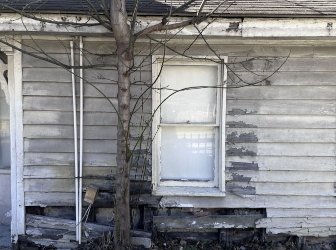
High-Pressure Water and Salt Decay: Industrial trucks are traveling at highway speeds through Malden Drive, creating massive splash zones. This forces road water and corrosive salt into the historic wood siding and foundations, leading to the severe rot and decay currently seen at the Norton House ( 1840) (Lubelli & Nijland, 2026). The side of the house that is not facing the road has no extraordinary decay.
2.2 Rand Exit
Seismic Foundation Damage: 19th-century structures were never engineered for the constant, heavy vibrations of 80,000-pound trucks. These rhythmic tremors cause settling and cracked mortar across the district (Caltrans, 2013).
According to a technical vibration assessment by Terra-Mechanics, Inc., included in the larger Market Street Corridor Study (Traffic Planning and Design, Inc., 2019), the force generated by heavy commercial vehicles has a documented physical impact on the structural underpinnings and facades of the district's 115 historic buildings. The data indicate that constant, low-frequency vibrations from trucks can lead to building material fatigue and foundation settlement in 19th-century masonry (Traffic Planning and Design, Inc., 2019).
Residents in Malden echo this sentiment by saying, “The vibrations are so bad that our house shakes when trucks wiz by. This is a historic house and it’s anything but peaceful,” and another resident says, “I’m having to completely redo my insulation and put in specialized soundproofing throughout my entire house. The trucks are just so loud you can’t sleep.” The former resident has a house built in 1836, and the latter has a house built in 1898. The entirety of the interior of the 1898 house has to be completely reconstructed due to the traffic on Malden Drive. This will cause a serious loss of historic value.
Environmental Degradation: Historic districts face a direct physical threat of decay caused by vehicle exhaust. A 2023 study implored cities to take active steps to reduce emissions to prevent the permanent loss of historic structures (Sagheb et al., 2023).
Noise Pollution: The resulting noise pollution makes it impossible to conduct the educational and historic lectures Malden is known for. This is documented in recent video footage of historian Larry L. Rowe lecturing to Marshall University, University of Illinois, and West Virginia State University educators and students at the African Zion Baptist Church, where heavy vehicle noise frequently rendered the lecture inaudible (Milhoan, 2026). These lectures are necessary in our pursuit of historical preservation and inspiring the next generations to preserve our history.
Speed: Reducing the speed limit along Malden Drive is a necessary deterrent to traffic in Malden. This has been proposed since at least the 1980s, and has still not been implemented, despite more and more commercial trucks speeding through the area. Reducing the speed is a low-cost way to provide a big impact.
A Compounding Problem: Consolidated School Transit Surge
The opening of Country Roads Elementary, located on the old DuPont Junior High lot in DuPont City, will serve as a breaking point to this decades-long hurdle in the preservation of over 200 years of history.
Transit Funnel: With the closure of Malden, Belle, Midland Trail, and Mary Ingles Elementary Schools, hundreds of additional buses and commuter vehicles will be flying through the historic district twice a day to reach the new site.
Conflict: Funneling this new wave of school traffic onto a road already being destroyed by XPO industrial freight and other commercial vehicles is a recipe for structural failure and a total loss of community walkability.
The Loss of Heritage and Tourism
Malden cannot survive as a heritage tourism destination if it functions as an unmanaged transit corridor. The current infrastructure plan sacrifices the economic potential of a unique West Virginia landmark for short-term logistics and school consolidation efficiency.
What to do? A Tale of Two Lewisburgs
The experiences of Lewisburg, Pennsylvania, and Lewisburg, West Virginia, serve as critical blueprints for Malden. Both towns have faced the challenge of being home to historic 1800s buildings and houses while also serving as active transit corridors, and both reached the same conclusion: historic preservation requires modern safety interventions.
Lewisburg, West Virginia
To address the issues in Lewisburg, West Virginia, the city moved beyond aesthetic concerns and addressed the physical and environmental degradation caused by heavy traffic on US 219 and US 60 (Johnson Mirmiran & Thompson, Inc., 2007).
The city successfully lobbied for lower speed limits on the main corridors (US 219 and US 60) as they enter the historic downtown, reducing the kinetic energy and subsequent vibration transferred to building foundations.
Lewisburg Pennsylvania
In Lewisburg, PA, a comprehensive Market Street Corridor Study (Traffic Planning and Design, Inc., 2019) was conducted to address the deteriorating state of the borough's historic core due to freight traffic – the same thing that’s happening in Malden right now.
Instead of trying to fund small fixes piecemeal, Lewisburg was granted a Safe Streets and Roads for All (SS4A) planning grant from the U.S. Department of Transportation. This moved the issue from a local complaint to a federally backed project (Borough of Lewisburg, n.d.). Lewisburg is using this federal grant specifically to address the types of safety concerns Malden has.
The two cities pursued extreme engineering measures to protect the town’s integrity, including implementing turning restrictions and even proposing the widening of corridors to 5-lane sections and the replacement of I-64 bridges to alleviate congestion. The solution in Malden can be much easier with the creation of a dedicated exit in Rand. This alternative route would achieve the same goals seen in both Lewisburgs and prevent the catastrophic loss of one of the last historically protected neighborhoods in West Virginia.
A Local Example
Looking at the exit at Witcher Creek can lend helpful inspiration. The situation is similar, with traffic on Route 60 and a train track running parallel. The main difference is the number of people and businesses that this exit would benefit. The need is much greater in our area. There is currently an emergency exit at the very end of Malden, which could be proposed, as well as land already owned by the Department of Transportation adjacent to Rand.
The number of businesses that would benefit from this exit (particularly small businesses) is not small. Some of the businesses and groups include churches, commercial trucking companies, daycares, artisanal manufacturers, convenience stores, schools, service trades like HVAC and electrical, commercial landscaping, and restaurants.
Norton/Patton House (1845) Damage, March 2026
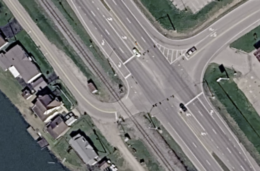
The intersection/exit at Witcher Creek
2.3 Booker T. Washington Heritage Trail
Walking the Ground That Shaped a Legend
Booker T. Washington did not just pass through Malden. He grew up here, worked here, worshipped here, fell in love with learning here, and carried what he absorbed in this small town into one of the most consequential careers in American history. He arrived in Malden barefoot, a nine-year-old boy who had walked roughly 210 miles from Franklin County, Virginia, with his family after emancipation. Malden has the physical geography to tell that story as a walkable, living experience. The Booker T. Washington Heritage Trail would connect the two historic cemeteries at either end of town into a continuous corridor along the river and railroad, threading through the same landscape Washington himself navigated as a boy.
The trail route follows a natural line through Malden's historic core, passing Booker T. Washington Park, the African Zion Baptist Church, the replica of his boyhood cabin, and the Ruffner cabin site on the Village Green. Along the river and the railroad (at a safe distance), interpretive signage at key stops would orient visitors and provide historical context without requiring a guide.
The Kanawha River itself deserves a moment of recognition along the route. Washington was so drawn to the wider world beyond Malden that he once stowed away on a riverboat headed toward Cincinnati. When he was discovered, rather than being put off the boat, he reportedly charmed his way into staying aboard by promising he would not be any trouble, a story that captures the resourcefulness and determination that would define his entire life. Standing on the riverbank where that chapter of his story unfolded makes it real in a way no classroom can replicate. Safety infrastructure along the trail's more exposed stretches, particularly near the railroad and the river, would include clearly marked crossings, protective barriers where appropriate, and lighting for visibility.
A self-guided audio tour is a natural companion to the physical trail. Visitors could access it by scanning QR codes at each stop, pulling up narration, primary source readings from Up from Slavery, and archival photographs on their own phones without needing to download an app or carry anything additional. Washington was a gifted writer, and his own words describing Malden are more powerful than any interpretive text we could write ourselves. Hearing him describe packing salt as a child, or walking through the door of the Ruffner household for the first time, while standing in the places where those things happened, is the kind of experience that stays with people.
For younger visitors, a trail passport, a simple printed or digital card that gets stamped or checked off at each stop, gives children a reason to engage with every point along the route rather than tuning out between the interesting parts. Schools and homeschool groups already touring Malden could incorporate the trail as a structured component of their visits.
Longer term, the trail has real potential as a regional heritage tourism draw. Malden sits within easy driving distance of Charleston and connects naturally to broader civil rights and African American history tourism routes through West Virginia and the mid-Atlantic. A trail of this kind positions Malden not just as a local history site but as a destination with national significance, a primary goal and thread throughout our Development Plan.
2.4 Landscaping
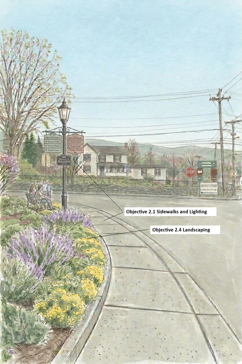
Preserving the Cultural Landscape of Historic Malden
A Strategy for Living History
The landscaping of the Malden Historic District is not merely a matter of curb appeal. To build up Malden as a premier heritage tourism destination, the landscape must be managed as a curated environment.
Restoration of the 19th-Century Streetscape
The physical space between the historic structures, specifically along Malden Drive, requires a unified landscaping vision.
Period-Appropriate Flora: Utilizing plant species common to the 1840s Kanawha Valley helps ground the historic buildings and houses in their original context.
Buffer Zones: Strategic softscaping (hedges, etc.) is essential to shield historic foundations from road spray and salt, acting as a natural filtration system for the 19th-century masonry.
The Science of Looking Nice
As discussed in the Sidewalks and Lighting section, research in environmental psychology shows that “cues to care” act as a social signal of active stewardship (Nassauer, 1995). When a neighborhood looks cared-for, it triggers a subconscious shift in visitor behavior, leading to reduced littering, slower driving speeds, and a higher level of respect for the physical structures. Data support this behavioral shift: “Buildings with high levels of vegetation had 52% fewer total crimes, 48% fewer property crimes, and 56% fewer violent crimes than buildings with low levels of vegetation (Kuo & Sullivan, 2001). As noted in a University of Maryland study on landscape perception, “plans can incorporate the cues such as mown borders, strategic plantings, bold patterns, and colorful flowering plants that shape favorable aesthetic outcomes” (Page, 2016).
We’ve put flowers at several of the signs and will continue to decorate for each season, adding more each time.
2.5 Benches and Trash Cans
Functional elements like benches and trash cans serve as the physical evidence of a community designed for people rather than just one that acts as a transit corridor. By placing historically appropriate benches and well-maintained trash cans throughout the district, the town signals that Malden is an active, protected heritage site, triggering that same subconscious shift in visitor behavior toward greater respect for the physical environment. Trash cans will reduce litter, and benches will encourage walkability with a nice place to rest mid-tour, if needed.
We have already begun this by placing benches at strategic locations like the bus stop near the Village Green and trash cans at high-traffic areas. We are starting to see a difference — these trash cans are being used! That trash would previously have been tossed on the ground.
2.6 Community Garden
Growing Food, Growing Community
A community garden in Malden is a direct investment in the health, self-sufficiency, and social fabric of a neighborhood whose residents deserve access to fresh, locally grown produce. In partnership with the Master Gardener Program, Friends of Malden Village is working to establish a community garden that puts fresh produce in the hands of the people who live here. When we asked what Malden residents wanted most, those surveyed mentioned a grocery store with fresh produce. This is one way to bring that need to life.
With a median age of 70.4 years, many of our residents face mobility limitations that make routine grocery trips to stores outside the corridor genuinely difficult. A garden within the walkable core of the neighborhood removes that barrier and provides consistent access to vegetables and herbs that support healthy aging.
The Master Gardener partnership brings real capacity to this initiative. Master Gardeners are trained volunteers, certified through a rigorous university extension program, with practical expertise in soil preparation, plant selection, pest management, and season extension. Their involvement ensures that the garden is not only planted but also maintained, productive, and accessible to residents who want to learn alongside them. Gardening together is one of the most reliable ways communities form lasting relationships, and Malden is a community that benefits from every opportunity to do exactly that.
The physical design of the garden will reflect the same intentionality that guides every other improvement in the district. Fencing will define and protect the growing space, walk paths will make the garden accessible to residents of all ages and mobility levels, and signage will identify plantings and connect visitors to the broader story of land and community stewardship that runs throughout Malden's history. Plant selections will consider the Malden Historic Preservation Society, Ltd.'s November 1981 report on historically important plants for the area, as well as the modern needs of residents. Together, these elements will signal that this is a cared-for, permanent community asset.
In our usual spirit of historical preservation, we will do an archeological survey as we dig, till, and take soil samples. This will include supervision by a historian, as well as metal detecting to ensure nothing is missed.
The garden also extends Malden's educational programming in a living, hands-on format. School groups touring the neighborhood, youth interns, and homeschool families can engage with the garden as part of their visit, learning about pollinators and the insects that sustain them, the life cycles of food crops, soil health, composting, and the broader ecological concerns of species endangerment and habitat loss that connect a small community garden to a much larger conversation about the natural world. These are lessons that stick precisely because they happen outside, with dirt on their hands, in a place they can return to and watch change over time.
Friends of Malden Village has been graciously given access to a plot by the local Dickinson family! The plot is visible, accessible, and positioned to serve the greatest number of residents. There is a stump in the middle of the property, which will be incorporated into a pollinator garden. This is the stump of a tree that likely saw the history that is so revered here in Malden.
The Friends have received so many donations from the community and beyond. The Master Gardeners have come to the location to help us collect soil samples for testing and for further planning. Blue Creek Detectors has done a sweep of the area and found various 1800s and early 1900s artifacts and completely mapped the area.
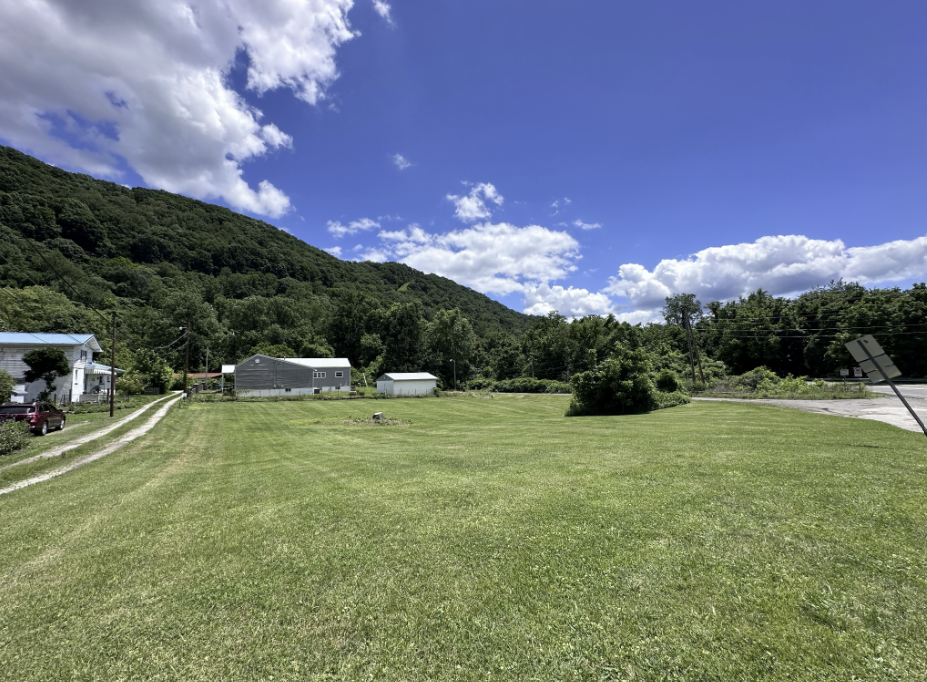
Site of the community garden
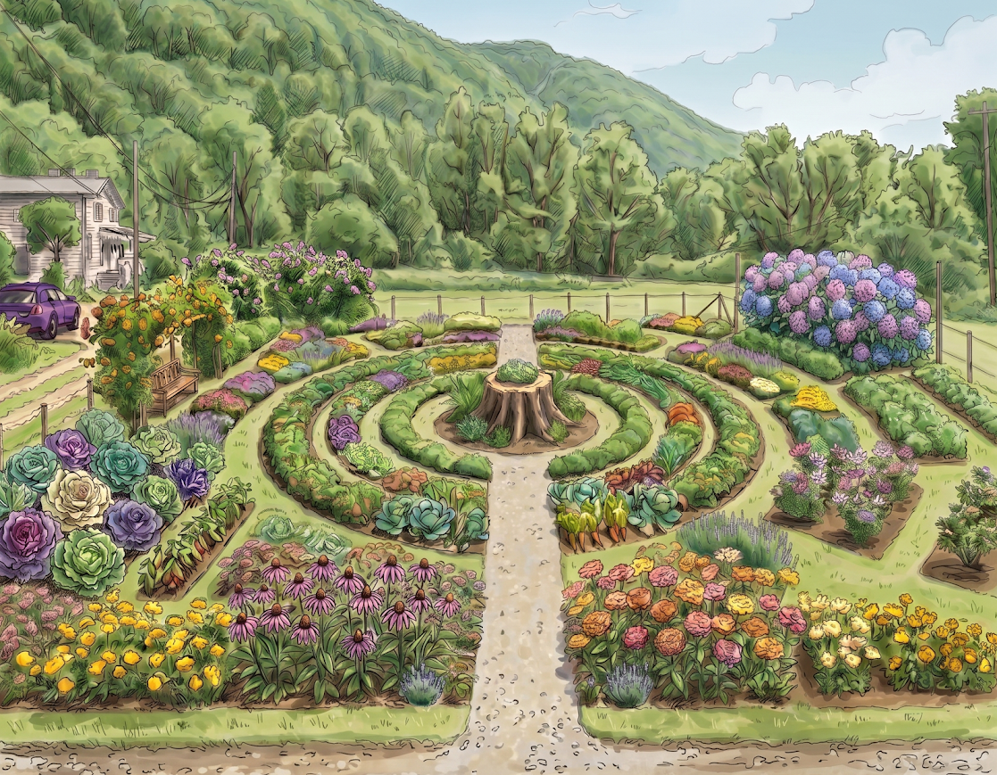
Mock-up of the community garden coming in 2026
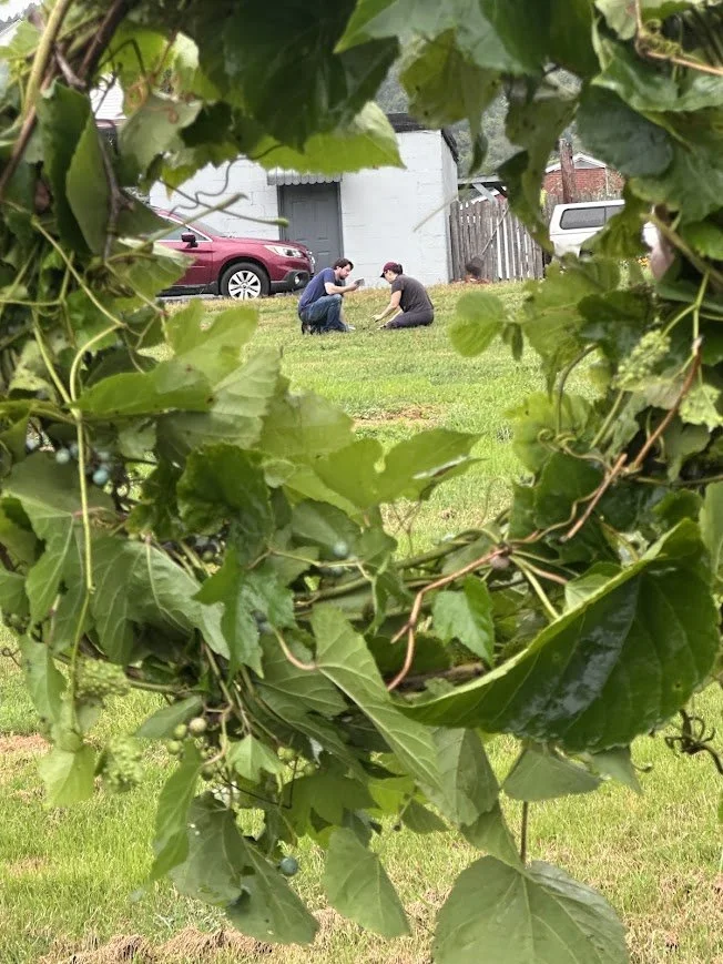
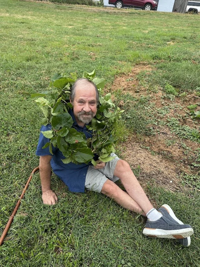
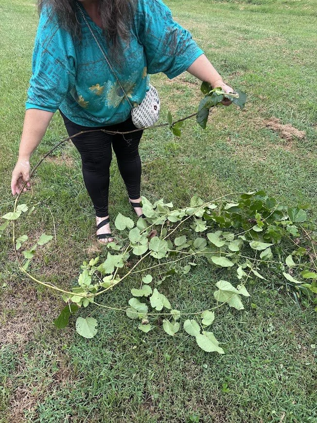
Taking soil samples and learning about plants at the Malden Community Garden Meeting